MudLog 8

OVERVIEW
MudLog 8
The Mud Log Drafting Tool
Products in the StarLog suite are sold separately, but downloaded together. Free trials are included for all products in the suite.
*WARNING: Log files generated by this Version cannot be read by program versions earlier than 8.6.1. If you are upgrading from an earlier version, be sure that your clients are also prepared to upgrade.
DETAILS
Why Buy MudLog 8?
Easy to Learn and to Use
- Whether you are an experienced computer user or not, you can quickly learn to use MudLog.
- If you are familiar with similar Windows programs, you will be off and running in minutes.
Saves Log Creation and Data Input Time
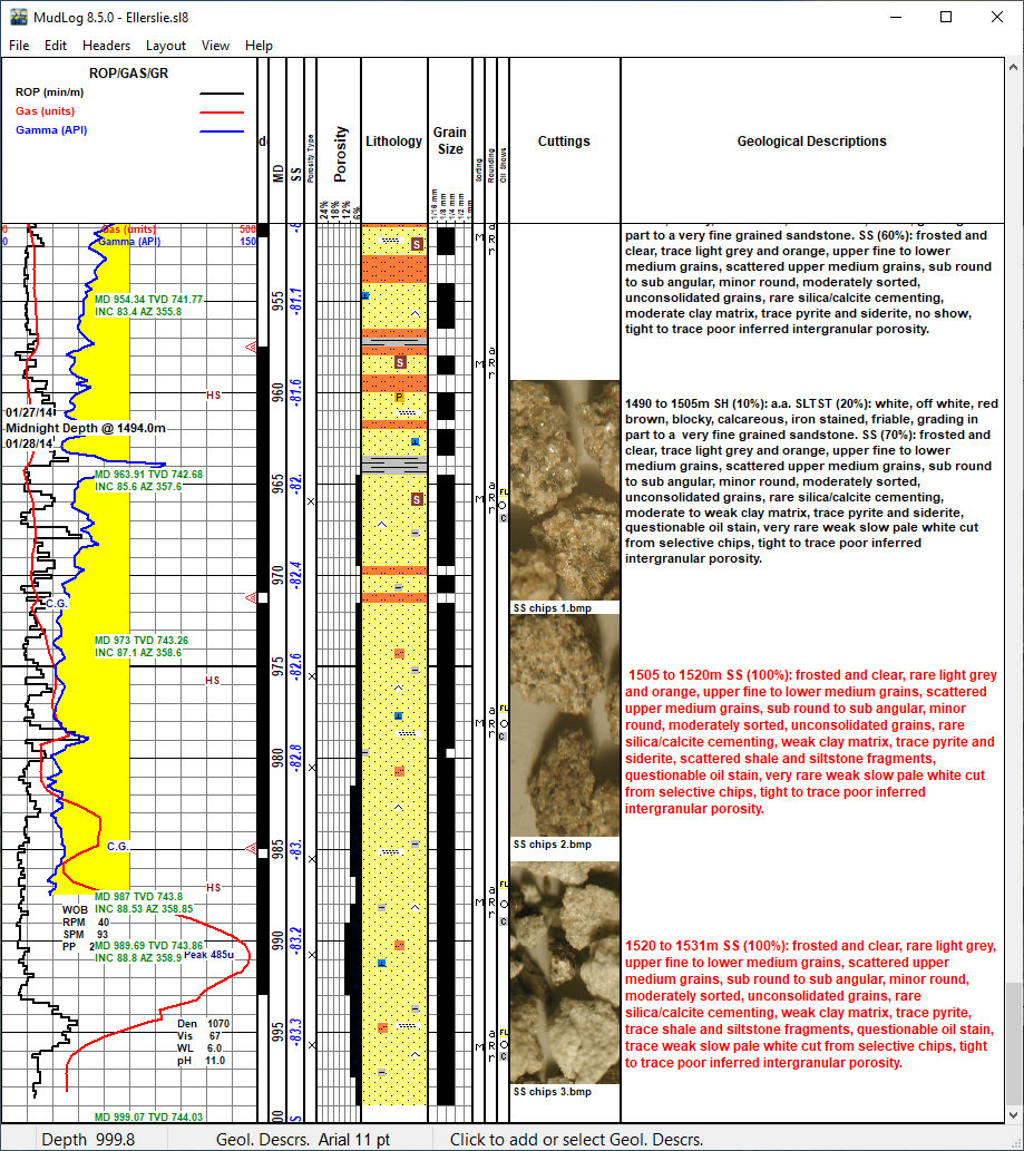
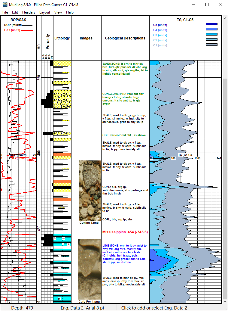
- Rapidly create well logs that are rich in data, including: ROP and Gas data, lithology and other symbols, engineering and geological descriptions, surveys, porosities, and grain sizes.
- Automatically import ROP, Gas and other data from gas detectors and EDR systems.
High-Quality Output
- Clear, precise, professional quality printed strip logs.
- Built-in header information for the well, the operator, the geologist, cores, DSTs, plan, elevation, etc. Plus custom header sections with your logo and other images.
- Support for continuous feed printers. (Plotter support is available in LogManager.)
- Import and export data to/from the log in a variety of formats.
Industry Standard
WellSight Systems’ products are used by:
- most Canadian geological consultants,
- mud loggers in all parts of the United States,
- all major oil and gas companies in North America,
- exploration companies throughout the world.
Affordable
- Whether you are an independent field geologist / mud logger or a major exploration company, you will quickly benefit from your investment in MudLog.
- Low annual license fee ensures that you receive the latest problem fixes and enhancements.
- See current pricing.
FEATURES
MudLog 8 Features
Easy User Interface
- Work directly on the strip log as it will appear when printed.
- Efficient point, click and drag interface.
- Change the depth range at any point during the project.
- Change the log scale or convert to TVD-indexed log.
- Scroll to any depth or go directly to a specific depth.
- Zoom in or out to see more detail or more of your log.
Log Types
- Use either feet or meters for depth.
- Several depth scales for well logs and core logs.
- Measured Depth logs can be converted to True Vertical Depth.
ROP, Gas, Gamma, and Other Data
- Two or more data curve tracks can display up to 10 data curves each.
- Each curve’s name and unit can be customized. For example, you could have ROP (min/ft), Gas (%), and Gamma (API).
- Each curve can be logged at its own data step. For example, ROP and Gas could be logged at 1 M steps, and Gamma could be logged at fifths of meters.
- Import curve data instantly from gas loggers or other sources in LAS 2 or LAS 3 (Log ASCII Standard) or delimited ASCII files.
- Enter or correct curve data directly, including Power Entry features like Shift, Add, Multiply, and Interpolate. Data values are plotted as you modify them.
- Live Data Acquisition (LDA) imports ROP, Gas, and other curve data automatically at regular time intervals from gas detectors or EDR systems.
- Customize each curve’s appearance: color, line style, width, filled wrapped areas, etc.
- Change data scales as needed at any depth.
Lithology, Mineral, Fossil, and Other Symbols
- Add and move symbols with a click of the mouse.
- Pre-loaded with a complete set of industry standard symbols, including: major rock types, fossils, minerals, stringers, textures, porosity types, sorting, rounding, oil shows, cores, & DSTs.
- Both percent lithology and interpreted lithology tracks.
- Where the supplied symbols do not meet your requirements, you can design and add new symbols.
Geological Descriptions and Engineering Data
- Import or export all geological descriptions in one step – abbreviating or expanding terms automatically.
- Geological descriptions and engineering data can be added and moved to any depth – just double-click where you want the text and start typing.
- Assisted Description Mode helps you to enter descriptions quickly and flexibly based on lithology intervals.
- Use cut, copy, and paste to quickly copy text to or from your word processor.
- Choose from font sizes 7 to 20.
Porosity and Grain Size
- Set the porosity or grain sizes for one depth or a range of depths with one click and drag of the mouse.
- Set individual grain sizes independently.
Headers
- Built-in Headers include: Well Info, Core, Operator, Comments, DSTs, and Symbol Legends.
- Custom Headers can be added: Plan, Elevation, Symbol Legend, and completely Customized Headers with any text and graphic arrangement.
Surveys
- Survey data can be plotted as a graph: Vertical Section, TVD, etc.
- Survey text can be automatically positioned at the wellbore or at the track edge.
- Survey data can be used to convert MD logs to TVD logs
Import Data
- ROP, Gas, or any other curve data in LAS or ASCII
- Surveys
- Geological Descriptions
Export Data
- ROP, Gas, or any other curve data as LAS or ASCII
- Combined LAS format integrates lithology and curve data
- Surveys
- Geological Descriptions
- Log image in JPEG or TIFF format
- PPDM
- All Data
Customization
Any of the following log characteristics can be customized:
- Depth Range
- Depth Scale
- Tracks in the log Layout
- Data Layers in each Track
- Data Curves: color, width, pattern, scale, linear vs. semi-logarithmic, data step
- Survey graphs (e.g. Vertical Section) and Survey Text
- Symbols and Symbol Libraries
- Headers and Legends
All customizations can be saved in Template files that can be used to quickly create new logs with the required format.
Quick Information Bar (Status Bar)
- Continuously displays the depth and the name of the track under the mouse cursor.
- Displays the current font size or symbol type for that track.
- Prompts remind you how to use each track.
Printing
- Use any page-oriented raster printer with continuous print capability.
- Print any depth range of the log, and optionally include log headers, symbol legends, and track headings.
- Logs can be printed at various standard scales. For example:
- Well logs: 1:240, 1:480, 1:600, 1:1200, 1:200, 1:500, 1:1000
- Core logs: 1:20, 1:48, 1:50
Capacities
See the detailed list of program capacities.
System Requirements
See the list of system requirements.